Wednesday, September 28, 2011
Monday, August 15, 2011
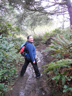
Eagle Creek to Tunnel Falls- 14 amazing miles!
A few months ago my husband and I registered for our first half marathon and when I clicked the register button the first thing that went through my head was "oh Shit!" How could I, a 33 year old, never physically fit girl, ever attempt to run or walk a 13.1 mile track...in less than 4 hours" I told myself that I would need to suck it up and just do it. This is something I have always wanted to try, just scared to try it. So, when I got the balls to plan a 12 mile hiking trip with some of my friends and step-daughter...I thought the same thing. I was petrified but, wanted to do it. From experience, I knew the Eagle Creek trail was not steep. It's an elevation gain of about 450 feet, from what one website states. If I was going to hike 12 miles, this would be the trail to take. This is also the trail (from previous blog entries) that I injured myself last September and
had to make the awesome journey to a local urgent care that accepted my insurance and be asked several times, if I was a drug addict...but , that’s another story.
 I enlisted my trusted hiking squad on this adventure: Amanda, Kelsey, Ida, and Becky. We introduced a new member to our club on this adventure as well...Haley.
To get to the Eagle Creek Trail, its exit 41 off of the I-84 east. At the end of the ramp turn right, follow the street all the way to the end and park as close as you can to the REGISTER HERE post. Its $5 per vehicle, per day, at the trailhead so, if you are unable to find parking close, pick up your slip, as you will need this on your dashboard or you will get a ticket, and then drive to find parking. I recommend you arrive at the trailhead before 9am or after 3pm to find parking. This trail is the one of the busiest in Oregon on the weekends. Some parking can leave you walking an additional 1/2 mile to the trailhead.
There are many different stops you can make at this trail...you can go to the Punchbowl which is a 2 mile jaunt (4 miles all together) into the forest, or you can go to high bridge which is, according to the signs, a 3.3 mile (6.6 miles all together) in and out hike. Or you can be crazy like us, and hike 6.5 miles (13 miles!?!) in and out to see tunnel Falls. The great news about the tunnel falls hike, is that once you get that deep into the forest, you can camp at several places. They are all first come first serve and some are big enough for a large group...just remember you have to carry your crap in and out. You can also get about a mile past tunnel falls to camp at 7.5 mile campground. Maybe when I get diagnosed as clinically insane, I will try to backpack in and out...I'll keep you posted.
For this amazing feat, I wore my trusted hiking boots with padded hiking socks, my sweat collector Danskin pants, a couple long tank tops, my trusted bandana and sweatshirt. For this hike, I also mole skinned the crap out of my feet (to no avail may I add...keep reading). For a 14 mile hike, I also brought lots of CARBS!! Fruit, trail mix, fruit snacks, turkey jerky, fruit...you could bring chocolate but, I have recently been told to go dairy and gluten free...so fruit...is my new beastie.
 We started this hike around 9am. We computed that it should take us approximately 6 hours to complete (photo and rest stops included). This hike, no matter where you want to stop is gorgeous! Trees, water, hills, and waterfalls! You will start off taking pics everywhere as it’s so amazing and makes you feel privileged to live so close to nature like this. But, please be careful on this trail ladies!! The trail in some spots is no more than 24 inches wide with a 30-100 foot drop off on the side. In some spots, where it is especi9ally narrow, there are cables for you to hold onto. In these spots, hikers going up and down need to be courteous with each other, go single file, and be patient! About a mile in, you will have a trail to the right to take you to a viewing spot for Metlako falls. Its am amazing view and you won’t hate yourself for taking extra time to visit this site....we did not stop to see this waterfall as our goal was 13 miles...and none of us wanted to add onto our lofty goal. At mile 2, is when you come to the trail that takes you to the water and a lower view of punchbowl falls. This is also where you can jump off of a 30 foot cliff into the water or sit down for a spell. Again, we did not venture down the trail because we were lazy AND there is an awesome viewing spot of Punchbowl falls a few steps farther down the trail and again we are attempting 13 miles. Once you pass punchbowl falls, the trail gets a bit wider at stages and the fewer people you see. You will pass a bridge a ways up...this is not high bridge...you will then pass another bridge...again don’t think this is high bridge because it’s not...when you get to high bridge you will UNDERSTAND why it’s called high bridge...and you now know your half way through the first leg of your hike. Stop here and enjoy the sites! There is also a great potty spot to the right after you cross the bridge! Take advantage of this spot...as there is not much to choose from the farther you go. Also, as we got father along..we spotted a snake and a scorpion!! No joke!
 You will pass some campsites and then you will come to another bridge that is just a few feet above the crystal clear water of the creek. There is a small rocky beach here that you can enjoy if the weather is right! The water is freaking cold so, be prepared!! We stopped and put our feet in on the way back. This bridge will also tell you that you have hit 4.5 miles! the next 2 miles, felt like they took forever!! At about 5 miles in, I got a bit dizzy and felt faint, so we stopped to rest a little while on some logs. I’m not sure why I felt this way but, I’m thinking it had to do with the closed in feeling or the fact that I started thinking about what if something was to happen...5 miles in...no place to land a helicopter...oh and the fact that since I am 5 miles in I have to walk 5 miles out...10 miles...oh shit....
Right around this area is where you will find some awesome camping areas! This is also where several trails meet up together and you will start seeing people again! You know you are getting close, when you reach the permit area sign! This is where other trail hikers, can pay their fee for the campsites if needed. This is also where we started picking up the pace! It was an exciting feeling knowing you are SOOOOO close to something that not a lot of people have made the venture to see in this world! Once you hit, what they call the Potholes, you are almost there!! you go around a few more bends and BAM!!
 You have made it to Tunnel Falls!! The most amazing waterfall I have ever been too!! What's so amazing about it is that there is a tunnel behind the waterfall that you walk in and you can stand RIGHT NEXT to a high powered, flowing, real life, waterfall!!
Now, let me give you some words of caution here...The trail is rocky and wet and slippery and about 18 inches (less than 2 feet) wide! BE CAREFUL! The drop is about 50 feet into the water below. When you get to this spot...you will get wet! protect your camera and belongings as much as possible! The 6.5 miles it took to get us here though, was well worth the reward! The waterfall is amazing!! I can't believe I waited this long to actually get my fat-ass upto it.
This was our turn around spot. This was also the time where we eat. So, we walked back, past the potholes, and found an awesome open campsite where we squatted and ate our lunch. This is also where, I realized my moleskin was crap and ill placed. I took off my boots and socks to find my feet blistered in places that I didn't even know existed. I brought some moleskin in my pack (as usual) and was able to re-place the mole skin on my feet. Even though I was able to replace the moleskin...it still hurt to walk...and the blisters were still there...OUCH!! FML I have basically 6 miles to go!! When we reached the 4.5 mile bridge, we stopped to put our sore feet into the ice cold water and allow some time to relax. After hanging out for about 20 mins we started our non-stop venture back to the parking lot. Besides my blisters, Ida wasn't feeling well, Becky was feeling some pain, Haley was feeling her knees, Amanda was feeling great, and Kelsey was feeling her calves for the first time in her 14 year existence.
I am not going to lie to you. The rest of the hike is a blur. It went fast but, slow...like...a half an hour, in my mind, took 3 hours! I could NOT WAIT to get back to Amanda's car and take off my boots, put on my flippy floppies, and REST!! When we reached punchbowl falls...I said out loud.."2 more freaking miles!!!" At this point, I ran out of water in my camel back...and it was warm outside...my feet hurt SO BAD, and I was barely touching the ground when I stepped. When I saw the parking lot, I almost cried! When I got to Amanda's car, I immediately sat down on the curb next to it and proceeded to take off my boots!! WHOA! OUCH! BOO!
When I got home, I immediately took a hot Epson salt bath, popped and bandaged my blisters well, my amazing husband helped me with this task. Took an Aleve and headed to the couch for the rest of the evening! I recommend you do the same!!
FINAL THOUGHT
Ladies, the next day I felt great! Remember, I have been walking and trying to be active for the last few weeks before attempting this hike. I would suggest you don't attempt this hike until you have had some hikes under your belt and never by yourself. basically, this hike is a half marathon, in boots, on rocks. If you don’t feel you’re ready...then build up until you are. I would recommend that you first start by going to Punchbowl falls and work your way to Tunnel falls. This hike is so amazing that my friend has asked me to repeat this hike with her and her husband in 2 weeks. I will let you know if I take her up on the invite… But, for right now, it’s been two days and I can still feel every inch of that hike on the blisters I have.
had to make the awesome journey to a local urgent care that accepted my insurance and be asked several times, if I was a drug addict...but , that’s another story.
 I enlisted my trusted hiking squad on this adventure: Amanda, Kelsey, Ida, and Becky. We introduced a new member to our club on this adventure as well...Haley.
To get to the Eagle Creek Trail, its exit 41 off of the I-84 east. At the end of the ramp turn right, follow the street all the way to the end and park as close as you can to the REGISTER HERE post. Its $5 per vehicle, per day, at the trailhead so, if you are unable to find parking close, pick up your slip, as you will need this on your dashboard or you will get a ticket, and then drive to find parking. I recommend you arrive at the trailhead before 9am or after 3pm to find parking. This trail is the one of the busiest in Oregon on the weekends. Some parking can leave you walking an additional 1/2 mile to the trailhead.
There are many different stops you can make at this trail...you can go to the Punchbowl which is a 2 mile jaunt (4 miles all together) into the forest, or you can go to high bridge which is, according to the signs, a 3.3 mile (6.6 miles all together) in and out hike. Or you can be crazy like us, and hike 6.5 miles (13 miles!?!) in and out to see tunnel Falls. The great news about the tunnel falls hike, is that once you get that deep into the forest, you can camp at several places. They are all first come first serve and some are big enough for a large group...just remember you have to carry your crap in and out. You can also get about a mile past tunnel falls to camp at 7.5 mile campground. Maybe when I get diagnosed as clinically insane, I will try to backpack in and out...I'll keep you posted.
For this amazing feat, I wore my trusted hiking boots with padded hiking socks, my sweat collector Danskin pants, a couple long tank tops, my trusted bandana and sweatshirt. For this hike, I also mole skinned the crap out of my feet (to no avail may I add...keep reading). For a 14 mile hike, I also brought lots of CARBS!! Fruit, trail mix, fruit snacks, turkey jerky, fruit...you could bring chocolate but, I have recently been told to go dairy and gluten free...so fruit...is my new beastie.
 We started this hike around 9am. We computed that it should take us approximately 6 hours to complete (photo and rest stops included). This hike, no matter where you want to stop is gorgeous! Trees, water, hills, and waterfalls! You will start off taking pics everywhere as it’s so amazing and makes you feel privileged to live so close to nature like this. But, please be careful on this trail ladies!! The trail in some spots is no more than 24 inches wide with a 30-100 foot drop off on the side. In some spots, where it is especi9ally narrow, there are cables for you to hold onto. In these spots, hikers going up and down need to be courteous with each other, go single file, and be patient! About a mile in, you will have a trail to the right to take you to a viewing spot for Metlako falls. Its am amazing view and you won’t hate yourself for taking extra time to visit this site....we did not stop to see this waterfall as our goal was 13 miles...and none of us wanted to add onto our lofty goal. At mile 2, is when you come to the trail that takes you to the water and a lower view of punchbowl falls. This is also where you can jump off of a 30 foot cliff into the water or sit down for a spell. Again, we did not venture down the trail because we were lazy AND there is an awesome viewing spot of Punchbowl falls a few steps farther down the trail and again we are attempting 13 miles. Once you pass punchbowl falls, the trail gets a bit wider at stages and the fewer people you see. You will pass a bridge a ways up...this is not high bridge...you will then pass another bridge...again don’t think this is high bridge because it’s not...when you get to high bridge you will UNDERSTAND why it’s called high bridge...and you now know your half way through the first leg of your hike. Stop here and enjoy the sites! There is also a great potty spot to the right after you cross the bridge! Take advantage of this spot...as there is not much to choose from the farther you go. Also, as we got father along..we spotted a snake and a scorpion!! No joke!
Right around this area is where you will find some awesome camping areas! This is also where several trails meet up together and you will start seeing people again! You know you are getting close, when you reach the permit area sign! This is where other trail hikers, can pay their fee for the campsites if needed. This is also where we started picking up the pace! It was an exciting feeling knowing you are SOOOOO close to something that not a lot of people have made the venture to see in this world! Once you hit, what they call the Potholes, you are almost there!! you go around a few more bends and BAM!!

Now, let me give you some words of caution here...The trail is rocky and wet and slippery and about 18 inches (less than 2 feet) wide! BE CAREFUL! The drop is about 50 feet into the water below. When you get to this spot...you will get wet! protect your camera and belongings as much as possible! The 6.5 miles it took to get us here though, was well worth the reward! The waterfall is amazing!! I can't believe I waited this long to actually get my fat-ass upto it.
This was our turn around spot. This was also the time where we eat. So, we walked back, past the potholes, and found an awesome open campsite where we squatted and ate our lunch. This is also where, I realized my moleskin was crap and ill placed. I took off my boots and socks to find my feet blistered in places that I didn't even know existed. I brought some moleskin in my pack (as usual) and was able to re-place the mole skin on my feet. Even though I was able to replace the moleskin...it still hurt to walk...and the blisters were still there...OUCH!! FML I have basically 6 miles to go!! When we reached the 4.5 mile bridge, we stopped to put our sore feet into the ice cold water and allow some time to relax. After hanging out for about 20 mins we started our non-stop venture back to the parking lot. Besides my blisters, Ida wasn't feeling well, Becky was feeling some pain, Haley was feeling her knees, Amanda was feeling great, and Kelsey was feeling her calves for the first time in her 14 year existence.
I am not going to lie to you. The rest of the hike is a blur. It went fast but, slow...like...a half an hour, in my mind, took 3 hours! I could NOT WAIT to get back to Amanda's car and take off my boots, put on my flippy floppies, and REST!! When we reached punchbowl falls...I said out loud.."2 more freaking miles!!!" At this point, I ran out of water in my camel back...and it was warm outside...my feet hurt SO BAD, and I was barely touching the ground when I stepped. When I saw the parking lot, I almost cried! When I got to Amanda's car, I immediately sat down on the curb next to it and proceeded to take off my boots!! WHOA! OUCH! BOO!
When I got home, I immediately took a hot Epson salt bath, popped and bandaged my blisters well, my amazing husband helped me with this task. Took an Aleve and headed to the couch for the rest of the evening! I recommend you do the same!!
FINAL THOUGHT
Ladies, the next day I felt great! Remember, I have been walking and trying to be active for the last few weeks before attempting this hike. I would suggest you don't attempt this hike until you have had some hikes under your belt and never by yourself. basically, this hike is a half marathon, in boots, on rocks. If you don’t feel you’re ready...then build up until you are. I would recommend that you first start by going to Punchbowl falls and work your way to Tunnel falls. This hike is so amazing that my friend has asked me to repeat this hike with her and her husband in 2 weeks. I will let you know if I take her up on the invite… But, for right now, it’s been two days and I can still feel every inch of that hike on the blisters I have.
Monday, August 1, 2011
Multnomah Falls to Wahkeena Falls-I DID IT FINALLY!
Before I tell you about this awesome hike, I need to give you a back story...
In the fall of 2009 my husband, step-daughter, and I journeyed to a little visitor stop called Multnomah Falls. This massive waterfall is one of the biggest tourist destinations in the pacific northwest and its one of the longest waterfalls in Oregon. My husband told me that the hike to the top of it was only "like a mile long" and free so we should go do it. We got into our tennis shoes, put on our rain jackets, and headed for a quick stroll to the top of the falls. First of all, he didn't mention that the top of the falls, even though a mile hike, was straight UPHILL with 11 switchbacks! JERK! This was probably the worst day of my life when I realized along with being fat, I also had been a smoker way to long, and I was incredibly out of shape. I made it to switchback 6 before I cried, pouted, screamed, and marched my big ass down the paved path, back to our car and this was the start of my journey...
In December 2009 is when a group of my closest friends decided we should start an outdoor exploration group and thus the start of this amazing blog. (tell your friends!)
 Fast forward to July 30th 2011. After almost 2 years of saying "Oh, Hell No!" to this hike, my friend Erin decided that we needed to do it and by do it, she not only meant the 1 mile, uphill, breathless, and demon of a hike but, the entire loop to Wahkeena Falls. So, when deleting her from my phone and facebook didn't work and she still found me...I reluctantly had to go with her.
 We got to the parking lot of Multnomah Falls off of I-84 around 10:30am. This was a perfect time to show up, as we were able to grab front row parking. On this hike, I wore my new Columbia Hiking boots, my Danskin cool pants (they are like leggings except they suck the sweat off your butt), and a few tank tops. Because the mornings are always cooler in the gorge, I brought a thermal sweatshirt that I could easily roll up and put into my pack or tie around my waist.
This hike is 5 miles....but, with seeing everything and walking from the parking lot, it was actually almost 7 miles. I brought lots of Cliff Bars and Power Bars to keep me up on this hike.
I am going to tell you in three words what to expect in the first 1.1 miles of this hike...PAIN, PAIN, and I hate this *&^%%, piece of ^%#*, *&^@) trail!!
The first 1.1 mile is all uphill (if you haven't guessed) and surrounded by tourists. This made Erin actually go slower than she wanted to go which was a plus for me! But, as you get up higher...some of the crowd clears and Erin actually wanted to run it...and this is when I contemplated pushing her over the cliff. But, I didn't. I MADE her stop at every switchback to let me catch my breath. I stretched my legs as they were already sore even though I had popped 3 ibuprofen. The entire way up this narrowed and paved path, I contemplated turning around or throwing a fit. I was OK with people thinking I was crazy at one point. When thoughts of anger were not filling my head, I thought about how this hike was the reason I wanted to hike. This hike was the reason for this stupid blog and my stupid boots and my stupid...well, you get the point.
On switchback 7....I realized I had made it farther than I ever had.
Then came switchback 8, and the people that we were following finally gave up.
Switchback 9, I was able to keep up with Erin and go for it! we were almost there...
And to prove I made it to the overlook...

The next 5 or so miles came easy, I had defeated my enemy. I am not saying this hike after the uphill struggle is easy, it was easy because nothing else could ever be as hard as fighting your enemy and winning!!
After you visit the overlook, go back to where you came from but, instead of turning left onto the paved path go straignt towards the water and a little bridge and you will be treated with several other waterfalls...Wisendanger, Ecola, Dutchman, Fairy and of course Wahkeena falls.
I suggest you get a copy of the hiking trails map at the information center or download it to your phone or ipod from here: http://columbiariverhighway.com/multnomah_falls_hiking_loops.pdf
 Once you get past the tourist trap called Multnomah Falls, the trail is dirt and rock. Please be prepared for this at even in 80 degree temps, the dirt is still wet and slippery. There are also plenty of rocks to trip on and the path is not very wide. Follow trail #441 and then at the junction with Larch Mountain Trail follow trail #420. Keep going on trail #420 for the remainder of your hike.
At this point in our hike, its pretty nice, there is a gradual uphill 1 mile or so but, my legs were numb to the pain at this point. We ran into some rangers, and after shooting the breeze with us for about 5 minutes about what is coming our way...they called us experienced hikers and told us to take care! LOL! They were just being nice but, Erin and I made sure that we wrote that down in our memories for future use!
 At the end of the hike to Wahkeena Falls, there is a return trail to Multnomah Falls. Take IT! Don't be dumb and walk along the highway...please!
FINAL THOUGHT
Fat girls, try this hike. It's OK to stop at every switchback and complain, scream, or yell. If all you can do is make it to switchback #6...at least you did it! You can always try again! Make sure to have a friend with you, who will help push you too! Erin was amazing at giving me encouragement and stopping with me even though she could have ran the whole thing without so much as smearing her make-up! This hike took us 3 and a half hours to complete and you can do it too!!
In the fall of 2009 my husband, step-daughter, and I journeyed to a little visitor stop called Multnomah Falls. This massive waterfall is one of the biggest tourist destinations in the pacific northwest and its one of the longest waterfalls in Oregon. My husband told me that the hike to the top of it was only "like a mile long" and free so we should go do it. We got into our tennis shoes, put on our rain jackets, and headed for a quick stroll to the top of the falls. First of all, he didn't mention that the top of the falls, even though a mile hike, was straight UPHILL with 11 switchbacks! JERK! This was probably the worst day of my life when I realized along with being fat, I also had been a smoker way to long, and I was incredibly out of shape. I made it to switchback 6 before I cried, pouted, screamed, and marched my big ass down the paved path, back to our car and this was the start of my journey...
In December 2009 is when a group of my closest friends decided we should start an outdoor exploration group and thus the start of this amazing blog. (tell your friends!)

 We got to the parking lot of Multnomah Falls off of I-84 around 10:30am. This was a perfect time to show up, as we were able to grab front row parking. On this hike, I wore my new Columbia Hiking boots, my Danskin cool pants (they are like leggings except they suck the sweat off your butt), and a few tank tops. Because the mornings are always cooler in the gorge, I brought a thermal sweatshirt that I could easily roll up and put into my pack or tie around my waist.
 This hike is 5 miles....but, with seeing everything and walking from the parking lot, it was actually almost 7 miles. I brought lots of Cliff Bars and Power Bars to keep me up on this hike.
I am going to tell you in three words what to expect in the first 1.1 miles of this hike...PAIN, PAIN, and I hate this *&^%%, piece of ^%#*, *&^@) trail!!
The first 1.1 mile is all uphill (if you haven't guessed) and surrounded by tourists. This made Erin actually go slower than she wanted to go which was a plus for me! But, as you get up higher...some of the crowd clears and Erin actually wanted to run it...and this is when I contemplated pushing her over the cliff. But, I didn't. I MADE her stop at every switchback to let me catch my breath. I stretched my legs as they were already sore even though I had popped 3 ibuprofen. The entire way up this narrowed and paved path, I contemplated turning around or throwing a fit. I was OK with people thinking I was crazy at one point. When thoughts of anger were not filling my head, I thought about how this hike was the reason I wanted to hike. This hike was the reason for this stupid blog and my stupid boots and my stupid...well, you get the point.
On switchback 7....I realized I had made it farther than I ever had.
Then came switchback 8, and the people that we were following finally gave up.
Switchback 9, I was able to keep up with Erin and go for it! we were almost there...
And to prove I made it to the overlook...

The next 5 or so miles came easy, I had defeated my enemy. I am not saying this hike after the uphill struggle is easy, it was easy because nothing else could ever be as hard as fighting your enemy and winning!!
After you visit the overlook, go back to where you came from but, instead of turning left onto the paved path go straignt towards the water and a little bridge and you will be treated with several other waterfalls...Wisendanger, Ecola, Dutchman, Fairy and of course Wahkeena falls.
I suggest you get a copy of the hiking trails map at the information center or download it to your phone or ipod from here: http://columbiariverhighway.com/multnomah_falls_hiking_loops.pdf

At this point in our hike, its pretty nice, there is a gradual uphill 1 mile or so but, my legs were numb to the pain at this point. We ran into some rangers, and after shooting the breeze with us for about 5 minutes about what is coming our way...they called us experienced hikers and told us to take care! LOL! They were just being nice but, Erin and I made sure that we wrote that down in our memories for future use!

FINAL THOUGHT
Fat girls, try this hike. It's OK to stop at every switchback and complain, scream, or yell. If all you can do is make it to switchback #6...at least you did it! You can always try again! Make sure to have a friend with you, who will help push you too! Erin was amazing at giving me encouragement and stopping with me even though she could have ran the whole thing without so much as smearing her make-up! This hike took us 3 and a half hours to complete and you can do it too!!
Monday, July 25, 2011
Elowah and Upper McCord Falls- Columbia River Gorge
 On a warm, sunny Sunday morning, three of my closest girlfriends and one amazing step-daughter ventured to Elowah Falls for an invigorating 2 mile hike. Elowah falls has been voted as one of the most gorgeous waterfalls in Oregon. The trail head is located right next to Yeon State Park off of I-84 in the Columbia River Gorge. We hit the trail after eating an amazing breakfast at around 11am.
 This hike starts right off the busy I-84 freeway. There is a small parking lot that will direct you to the beginning of the trail with a large, dark sign. this two mile hike is kind of intense for the first mile or so. After you hike a bit into the wilderness, the trail forks in three. Go to the right and see Upper McCord Creek, venture straight and hook up to an old trail, or go to the left to see Elowah falls. We read that you should go left and then when you come back from Elowah falls go to the right to see Upper McCord Creek falls...which is exactly what we did.

There are some spots that are tough to climb....and if your scared of heights this hike might not be your best option. Parts of the trail are high and tight, and with crowds in the summer there was many times we had to stop to let others pass. There are two spots where a tree has fallen over the trail and a metal pipe too. Be careful, you will have to crawl over these fallen bits to proceed along the trail. But, if you are able to manage these things, you will be reward with an amazing waterfall! The large rock walls that surround the waterfall might give you vertigo with their colors and size and the waterfall pours into a small pond that looks like it would be a great place to soak on a very hot day. Spend some time here taking pics. We didn't go farther than the bridge as some other hikers told us there was nothing more to see on the trail besides the freeway.

As you make your way back the way you came and then proceed to Upper McCord Creek falls, the trail is a bit more strenuous and high. But, the views of the Columbia river are amazing! The views of the river, in my opinion, are more impressive then McCord Creek Falls.
Once you see the waterfall, if you head up a muddy hill at the end of the jungle (and I mean you will get slapped with branches and attacked by bugs) you can take a dip in the 3 foot deep pool at the top. But, be careful as this pond leads directly to the waterfall.

FINAL THOUGHT
This is a great hike for a beginner! It's fast, its pretty, and its not too hard to do. This hike will make you try many more Gorge hikes in the future I promise. I recommend that you lace up your boots, squeeze that booty into some pants and go see this waterfall!
Monday, April 4, 2011
Clatsop Loop Trail- Ecola State Park
It's been a long time since I have hiked so, I wanted to start somewhere small and convenient...like the Oregon Coast in April!! So, my bestie Becky and I drove to Ecola State Park, near Cannon Beach, and went on a Moderate (uh huh) 2.6 mile hike into an old Forest! SWEET!
 But, this hike is actually close to 4 miles people! Be prepared too, the first 1.6 miles of it is a steady incline. It will make your heart pump loud and fast as sweat trickles down your face and neck leaving you gasping for air five minutes in. We started at the Indian Beach Trail head located in Ecola State Park. The cost to park here is $5 for an all day pass. Once at the pay machine, take a right to head to Indian Beach. This road is very small and windy and at times only enough room for one car to pass. Becky, gets car sick so she had to keep the window open the entire time, hence she drove home when we left.
Once we parked at the trail head and got prepared for the cold (42 degrees), wet (Oregon drizzle), sometimes sunny (What is the orange thing in the sky?), sometimes hailing (sleet), and blustery(its the Oregon coast) spring conditions.
There are two ways to experience this loop you can either A. stay on the gravel road by going straight past the bathrooms or B. turn left to the viewpoint and go up the rugged dirt trail. We decided to start with the gravel road and this is how I recommend you start as well. The hike up is grueling and sometimes I re-thought my hiking desire and wanted to turn around and cry. My legs felt like jello and I had to stop about half way up to eat a trail bar and take off three of the four layers I had worn. Not to mention that the hike up, all though beautiful is boring!! I kept having to remind myself that the view at the top was the ultimate goal and with this kept pushing myself up the steep terrain. One of my favorite things about a hike like this is that you lose 2/3 of the people right around the middle point as most "day hikers" don't realize how challenging some hikes can be and they turn around.
Once you make it to the top, and you will, your legs will be burning, your head will be sweaty, but you will have to time to recoup...trust me! At the top of the trail crossing ( keep going straight to the view point don't turn left to follow the trail) You will see a primitive camping area and 3 cabins. These three cabins have a communal fire pit and 4 wooden bunks inside. These cabins are free of charge! They will keep you warm and dry if you decide to camp for a day or two.
 Across the trail from the campsite is an old World War II radar bunker. You can verge to the left and get on top of the bunker to see the look out posts and take some pics. The entrance's to the bunker are chained off which made me sad.
 Once you have had time to check out the camp and bunker, continue forward and go down to "Clark's View". Be careful here, its very high up, and it was very windy. There is a small opening in the trees to see the beautiful pacific ocean and the old Tillamook light house or Terrible Tilly as its called. This is a great story to read about www.lighthousefriends.com

Now that you have made it up the steep hill to the amazing viewpoint, turn around and head back to the trail crossing past the campground. Once at the sign, head to your right onto the Clatsop trail loop. This is where this hike becomes breathtaking! I suggest you wear pants and water resistant or proof hiking boots for this hike. In April, this trail was muddy, slippery and wet! At times we had to climb over fallen trees, walk in a rain-made stream, and step through some serious mud puddles. This trail is also a steady decline.
 As you make your way through the tree's you will start to see the ocean about a mile in. Along this side of the trail there are plenty of picture opportunities. I am going to tell you to stop and take in the views around you! It's spectacular! This is why I suggest you come down this way instead of the other way! As I got closer and closer to the end my excitement level sky rocketed! I just wanted to see more of all the amazing views that some people never get to see in their lives!
 The trail finally comes to an end exactly where you started on the gravel road. You will see the parking lot to your right. Becky and I then took a walk around Indian Beach before getting into our car for the drive home. We were tired and muddy but, felt amazing.
We felt so amazing that we stopped by Ecola State park on the way out to take in the sights. I would suggest you do the same! I rate this hike highly and I can't wait to take more of my friends there during the summer!

Once we parked at the trail head and got prepared for the cold (42 degrees), wet (Oregon drizzle), sometimes sunny (What is the orange thing in the sky?), sometimes hailing (sleet), and blustery(its the Oregon coast) spring conditions.
There are two ways to experience this loop you can either A. stay on the gravel road by going straight past the bathrooms or B. turn left to the viewpoint and go up the rugged dirt trail. We decided to start with the gravel road and this is how I recommend you start as well. The hike up is grueling and sometimes I re-thought my hiking desire and wanted to turn around and cry. My legs felt like jello and I had to stop about half way up to eat a trail bar and take off three of the four layers I had worn. Not to mention that the hike up, all though beautiful is boring!! I kept having to remind myself that the view at the top was the ultimate goal and with this kept pushing myself up the steep terrain. One of my favorite things about a hike like this is that you lose 2/3 of the people right around the middle point as most "day hikers" don't realize how challenging some hikes can be and they turn around.
Once you make it to the top, and you will, your legs will be burning, your head will be sweaty, but you will have to time to recoup...trust me! At the top of the trail crossing ( keep going straight to the view point don't turn left to follow the trail) You will see a primitive camping area and 3 cabins. These three cabins have a communal fire pit and 4 wooden bunks inside. These cabins are free of charge! They will keep you warm and dry if you decide to camp for a day or two.


Now that you have made it up the steep hill to the amazing viewpoint, turn around and head back to the trail crossing past the campground. Once at the sign, head to your right onto the Clatsop trail loop. This is where this hike becomes breathtaking! I suggest you wear pants and water resistant or proof hiking boots for this hike. In April, this trail was muddy, slippery and wet! At times we had to climb over fallen trees, walk in a rain-made stream, and step through some serious mud puddles. This trail is also a steady decline.


We felt so amazing that we stopped by Ecola State park on the way out to take in the sights. I would suggest you do the same! I rate this hike highly and I can't wait to take more of my friends there during the summer!
Wednesday, August 18, 2010
Eagle Creek to Punchbowl Falls September 2010

To get here take I-84 to Exit 41 and turn right follow the street all the way till it dead ends and park. It's a $5 day pass and please pay it as we saw lots of cars with tickets! This hiking spot is extremely busy...and for the small paths its a bit too busy! I would recommend not to bring children or animals on this hike as it does have some super steep cliffs with not alot of walking room.
On this hike I wore my new cargo knee length shorts, T-shirt, and brought a fleece jacket with me. As always, I suggest that you pack water, snacks, and maybe a lunch! If you choose to go into the water, bring extra clothes and shoes.
You can view 3 waterfalls on this hike and all three of them are amazing! If you are able to make it down to the water...getting up the hill is challenging and don't look for easier ways up. We saw lots of people trying to take a quick route out of the water and got stuck going at a 60 degree angle path! Bad news!!

Because I am klutzy...I hurt myself (again) hiking. I twisted my ankle..the same ankle from July. So make sure to watch were your walking, bring your trekking stick, and wear good shoes. This hike is rocky in places. If I didn't have my hiking boots on...I think I would have broken it this time!
FINAL THOUGHT
This is a perfect long hike for those new to hiking! This is a pretty flat hike (unless you head down to the water) and there is so much scenery to see. Also, since this is a very busy hiking trail there are people to talk to you in the event you get lost or have questions. I would recommend that you get here early (before 9am) or late (after 3pm).
Horsetail Falls and Triple Falls- August 2010
 First of all, if you would like to hike this trail get here early on weekends or try this on a weekday. We arrived around 10am and had to wait a few minutes to find a parking spot but, when we were done we had to fight to get out of our parking spot and had to tell three different cars to back off so we could pull out and they could park there.
 My husband and daughter came with me on this hike. The weather forecast called for 75 degrees and sunny so I wore a tank top and capri cargo's and of course my trusted hiking boots.
Some websites state this hike it 3.8 to 4.5 miles with an elevation gain of 400 to 700 feet. I can tell you this...this hike is both bad and good. The hilly spots are killer...including the first .4 miles. Its straight up!! Then the trail goes flat and then goes down down and then up up. Basically, if your not prepared this hike will suck! We saw lots of people give up at Ponytail Falls or at the high bridge. DON'T GIVE UP!
 This is an wonderful day hike in the gorge. Its a bit crowded which clogs up the trail but, it clears out the farther you go.
FINAL THOUGHT
Take your time with this hike and don't make this your first adventure. We saw alot of people give up and turn around and it was sad because when you reach the top you can play in the water.
Wednesday, July 21, 2010
Wahclella Falls- May 2010 AMAZING!!

My amazing and fantastic husband turned 35! He didn't want a party or any type of present(weirdo) so we took him to Wahclella Falls near the Bonneville Dam off of I-84. This was described as an easy 1 mile in and out on all the hiking websites I could find. Easy, you mean in you stay on the lower trail and don't mind your calf's burning from exhaustion as you climb up a freaking hill!
On this hike I wore a pair of REI pants, boots, my fleece pullover and a t-shirt.

You will think you have been walking for a really really really long time but, your not. It's a one mile in and one mile out with plenty of places to stop and enjoy the scenery and maybe eat a lunch if you packed it. There is also a place to play in the water or have your doggy play in the water. But, I am not going to lie..your gonna hate life for a few minutes as you go up stairs and down stairs and climb up hills and down hills...so be prepared to want to hurt someone or something...but please don't.
FINAL THOUGHT
This was one of the most amazing waterfalls I had seen to date. If your fat and want to get out of the house and take your significant other or kids somewhere for an afternoon check out this hike. It is a $5 parking fee at the trail head which starts at the end of the parking lot. I was not sore the next day so that's always good if you want to do this on a Sunday and have to work on Monday.
Waterfalls and Crater Lake OH MY! June 2010

It was family vacation time in my household!! We decided to finally visit Crater Lake in central Oregon. Without much planned for our 2 day journey we found an awesome campsite right on Diamond Lake. After setting up our camp we went in search of crap to do to fill our time. We didn't want to visit Crater Lake day one as we arrived around 1pm and wanted to spend as much time there as possible...it is summer right? After driving around the area for about an hour we stopped by the friendly information center to get ideas of things to see...and see we did!
There are close to 50 waterfalls and hikes near Crater Lake! As you can see from previous posts I LOVE waterfall hikes. To me, hiking in to see something is far better than just hiking just to hike (see Forest Park hike post). As a fat girl I gotta have something to keep me going! Motivation I like it!!

We went to 4 waterfalls on day one. We started with the farthest one away and worked our way back to camp. The first waterfall we saw was Toketee Falls. This hike can be a short 1 mile in and out OR you can hike to the hot springs...which we might do someday in the future. This was a fantastic hike but, fat girls out there if you HATE the StairMaster then you will HATE this hike. It's all stairs! Up and down the entire way. I think we counted almost 800 steps. Besides the stairs this was a beautiful hike into the wilderness with lots to see! We came here on a Wednesday and it was very crowded though! The final stop is a man made viewing platform that caused me Little concern as I am not a big fan of heights. The waterfall was amazing though and made this adventure well worth it!

We then visited Watson Falls a few miles back down the road. This waterfall is amazing as well but, we didn't complete the entire hike up to the viewing area because my fat ass was too tired! From the parking lot you must walk up a hill to get to the trail head. You then must hike up many switchbacks up and up and up and up! A switchback for those who are just starting to hike are areas where the trail loops up and down a hill..basically it cuts back on its self. At one point, we found a little watering hole and dunked our heads and allowed our hiking dog Jefferson to drink some very cold water. That helped us continue our adventure but after the water dried up...so did I! There is many fantastic areas to sit and relax and the trail itself is very well maintained. I think that if you want to see just one waterfall...this is the one to see.
Our third stop was at Punchbowl Falls. If you want an awesome waterfall to see without any freaking hiking...this is the one too see! The waterfall sits in a camping area with a great viewing platform. You can hike more of this area if you want to but like I said before...I need something to hike too for motivation! You can walk down to the punchbowl here and take a dip if you want or just get awesome pics.
Our final stop was to Clearwater Falls, again no hiking necessary here!! And after 2 grueling hikes before in the day I was glad to hear that! Clearwater falls is amazing as well and there are plenty of places to get your feet wet or sit down and relax after a long hot day in nature. We took lots of family pics here and enjoy our time with each other before heading back to camp.
A word to the wise here...if you are going on an adventure like this...please make sure to bring BUG SPRAY!! Don't run out like we did...The mosquito's are KILLER!! My family and I were COVERED with bug bites for the next week! I had those blood sucker injuries from the top of my head (and I was wearing a hat) to the bottom of my feet (I had boots on). My husband even went to the local market and bought candles, spray, and fabric sheets. NOTHING WORKED! These little bastards made our night miserable...we checked into the tent around 9pm, missed the sunset and sat around playing cards and reading. FUN TIMES!
In the morning we packed up camp and headed over to Crater Lake. This ladies is a wonderful place to see!! No hiking necessary if you don't want to but, you can still take in all the views from the Rim trail from your car if you want! Go see this place if you haven't!! When we left Crater Lake around noon we decided we wanted to see one more waterfall...Salt Creek Falls the 2nd longest waterfall in Oregon.

FINAL THOUGHT
Being a fat girl my whole life adventures like this to me were dumb and freaking boring! I have made a goal to see at least the top ten waterfalls in Oregon before the years end now. I have 3 down so far! If you want something fun to do besides watching a movie or TV...go out and do these hikes! Its pretty much low cost and you can say that you did it! My step-daughter is 13 and she has come with me on 3 of my adventures and she loves the time we get together!
Latourell Falls Hike July 2010

I convinced my friend Nikki that we had to go on an adventure together and I chose this special place to make that dream a reality. To get here take exit 28 off of I84 turn right at the first stop sign like your going to the Vista House ( which is also something we did together even though I was in pain and covered in dirt...more on that later)
For this hike I wore Hiking shorts, my cushioned socks, boots, and a t-shirt. It was going to be 75 degrees that day and the hike is a 3 mile loop up a hill and down an hill.
Nikki and I arrived at about 10am at the trail head and proceeded to go up the hill near the picnic tables instead of walking down the hill to the main waterfall as there were too many visitors and I looked like crap...which I tend to do for all my hiking adventures. Why put on makeup when you basically going to hell anyways...right?
Latourell falls is 3 waterfalls in one. When you park your car at the trail head you will see one. As you walk up the mountain you see a small middle falls and when you reach the bridge to loop you around you meet #3 which I think is the prettiest of all.
Now, even though Nikki and I went in July the ground was still wet with all the water that falls of the hills so be CAREFUL. Also, if you bring your dog with you please be prepared that there are lots of people and lots of dogs(I will explain in a second). If your a heavy girl like me take your time with this one...I rushed to the third waterfall without stopping to impress Nikki only to almost run out of gas towards the end, which I think was the start of my demise.
After you reach the third waterfall the trail becomes confusing and hard to hike...broken down areas make it easy to fall or twist your ankle...none of these I did here. My advice is to wear boots and stay to the left as much as you can. At one point I thought we were lost but we can upon a viewing spot of the Columbia Gorge and knew we were coming down. YEAH we made it down without a scratch! But, the trail dumps you out right onto the Columbia River Scenic Highway and if your not careful you will come face to face with a car. You must turn right at the road and cross a small bridge to return to the parking area to get your car. People drive like jackass's!
When we arrived back at the parking lot we decided that since we were awesome and completed that hike with no issues "lets walk down the trail to the main waterfall and get more pictures." That is when my dog Jefferson saw the love of his life...a small white rat terrier. Jefferson, may I add, is a 80 lb lab and Shepard mix. As I tried to restrain Jefferson from meeting his new love a dumb jerk with a camera and video camera was blocking the ENTIRE path (People don't do this it just makes you look like a jerk and if you do do this...help a sister out when she falls on her face!!!) Jefferson pulled me to the left to avoid said jerk to meet his lady love. I didn't realize the path had a 5 inch drop off the left side into mud. This is where my ankle twisted beneath my body weight bent in half, threw me to my knee, and then spit me out onto the wet and dirty pavement. Yeah me! Its always funny to see a fat girl fall!
After whining in pain for a few moments I was able to sit up and tend to my wounded knee with some Kleenex. My ankle was screwed but, since I could walk on it (gingerly and while limping) I knew it probably wasn't broken..THANK GOD my boots are high tops!
Ladies...don't do this...don't be like me...take your time and BE CAREFUL! This has been my first hiking injury and kept me on the bench just long enough to start this blog but, I gained 5 lbs in the process!!
FINAL THOUGHT
Don't do the whole hike if its your first time up to bat. Let this be like one of those hikes you do to prove how good you are at hiking. Make sure you have a friend with you and I would recommend that you not take your dog just because of all the people that tend to gather here on weekend afternoons.
Subscribe to:
Posts (Atom)